Emotional maps
What are the spatial preferences in your city?

What are emotional maps?
Involve your citizens actively
The Emotional Map is a tool that offers the opportunity to actively involve citizens in gathering information and opinions about the localities in which they live. It is a tool for the participatory planning of public spaces.
How to use the results?
Municipalities most often use the results as supporting documents for planning investment projects, creating transport concepts, or providing information to municipal police.
Process

Let’s plan in together
Beginning
After the initial contact and agreeing on the details of our cooperation, we will define together the questions to be answered by the interviewees and the scope of the area to be mapped (housing estate, urban district, the whole city).
Usually there are 5 – 6 questions, which can be of two types:
General questions
- Where do you feel comfortable?
- Where do you play sports?
- Where do you feel unsafe?
Specific questions
- Where do you have a parking problem?
- Where can’t you get to using public transport?
- Which services do you think are missing in Březina housing estate?
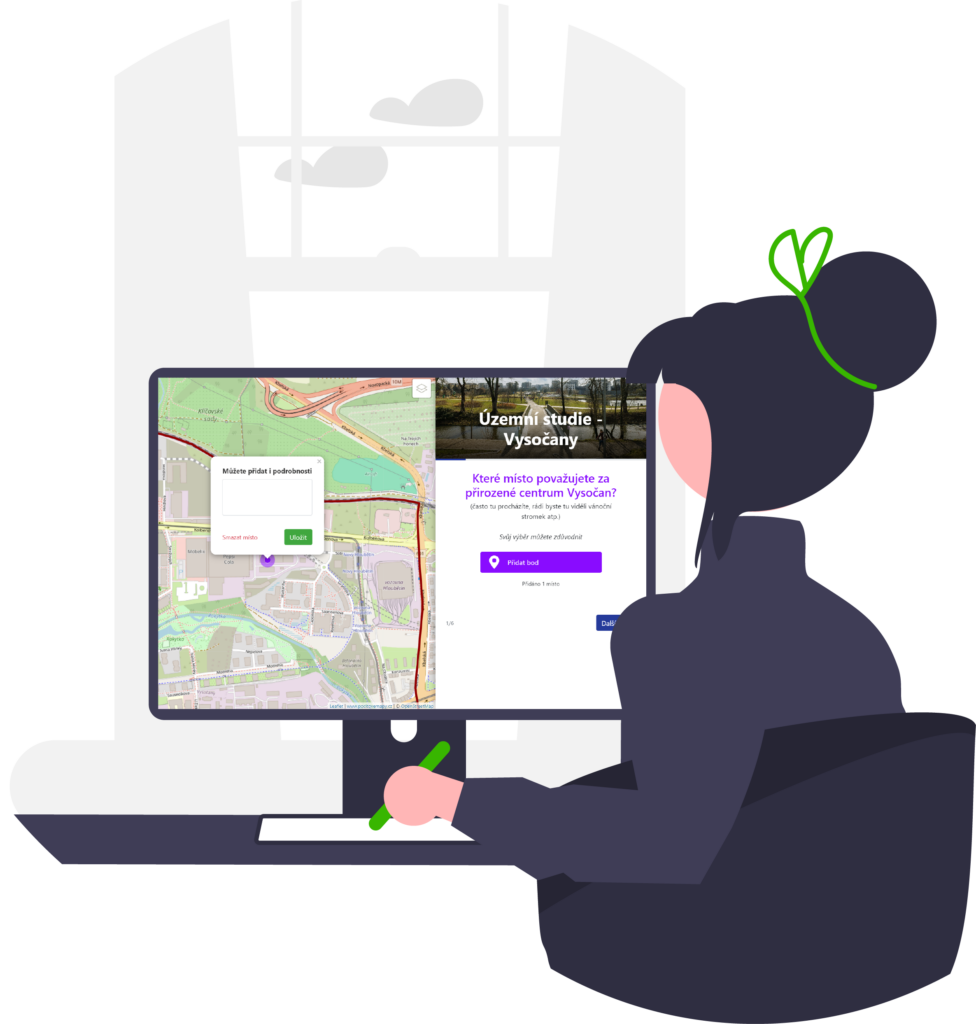
Let’s map it
Data collection – online or offline?
The next step is the mapping itself. This can take two forms. Both can be done simultaneously, or you can choose just one, depending on which way of reaching out to citizens suits you better. Combining the methods will ensure a greater reach of the mapping and make the results more relevant and representative.
Offline version
The mapping is done directly with the inhabitants of the municipality in various meetings or debates with citizens (but you have to organise these).
Online version
Another option is to create an online version of the questionnaire that will run on our website. You can direct your citizens to it using the municipality’s website and the local newsletter. The map can be embedded on your site using iFrame, etc. Users can then complete the map from the comfort of their own home.
Take a look at a sample of such an application.
What do we know know?
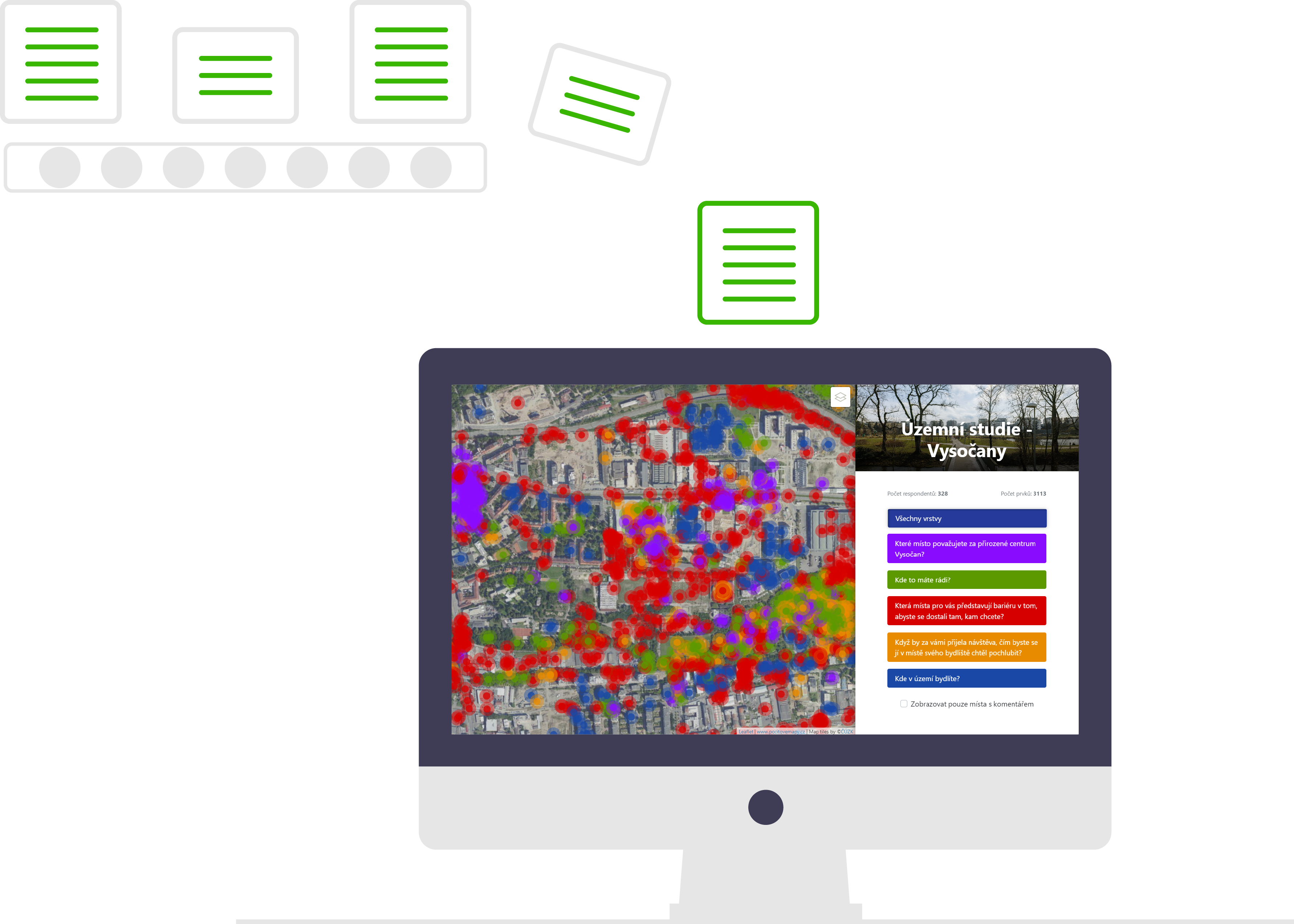
Analysis and results
We will process the collected data from both options in a geographic information system (GIS), evaluate it and create summary maps for each question.
We will provide you with basic summary maps, the raw collected data in a GIS compatible format (shapefile or GeoJSON), a preview of respondent demographics, a list of comments with GPS coordinates, and a web-based preview of the results that will be on the site where the data collection was previously conducted.
Important partners


How much will it cost?
Choose a suitable variant from the price list
We offer our services in basic and extended versions. But we are also able to meet your specific requirements and prepare an individual offer for you.
Basic
400 EUR
✓
up to 5 questions defined by you
✓
simple questionnaire at the end of the map – age, gender, etc.
✓
results as raw data
✓
simple overview maps
✓
web-based public preview of results
Advanced
800 EUR
✓
up to 10 questions defined by you
✓
answers using points, lines or areas with the possibility to add comments
✓
comprehensive questionnaires for each question, during mapping or at the end of the map
✓
results as raw data
✓
simple overview maps
✓
web-based public preview of results
Individual
Price by agreement
✓
anything you didn’t find in previous offers
✓
we are able to code most of the requirements in addition
✓
advanced data analysis
✓
comprehensive visualization of outputs
✓
effective map products or infographics
Feedback from clients
More than 10 years of experience throughout the Czech Republic and abroad
⭐️⭐️⭐️⭐️⭐️
Department of Geoinformatics, Palacky University Olomouc
“Emotion maps have been used in our research activities in cooperation with public administration several times. I very much appreciate the possibility to customise the application for a given purpose. This has allowed us to have an intuitive tool for primary school pupils to map problem areas around their school. For the second time, we used the app to assess mosquito activity in Litovelsko Pomoravje as perceived by ordinary citizens and tourists. Last but not least, there is also great communication with suppliers.”
⭐️⭐️⭐️⭐️⭐️
Mott MacDonald
“We’ve worked with emotional maps twice before, and we’ve always had quite specific requirements. They have always been helpful, the map has worked great on both computer and phone, and we have collected almost 4000 suggestions. The cooperation was fast and flexible, we will definitely be happy to return in the future.”
⭐️⭐️⭐️⭐️⭐️
National Healthy Cities Network
“Emotional maps are a great tool for public engagement. Members of the National Healthy Cities Network (www.zdravamesta.cz) use them extensively both at live events and online. It is a proven method of participation that is intuitive for citizens and does not require any complicated training or explanation. As a result, cities use the map to get citizens’ feedback on the selected area – which can be general or thematic (safety, accessibility, leisure opportunities, etc.). This is a valuable basis for further urban development planning.”
⭐️⭐️⭐️⭐️⭐️
City of Přeštice (CZ)
“In 2023, the City of Přeštice used the Emotional Maps, which provided important feedback from its citizens. We have learned about places that need repair, discovered locations with untapped potential, or those that need change. The project was very valuable and provided a lot of input that can be useful in the development of the new strategic plan.”
⭐️⭐️⭐️⭐️⭐️
Studio MEZIDOMY
“To work with space, it is important to have an overview of how users perceive it. The entries in the emotional map give us a very detailed picture of this. We also tried them for interiors and they worked well there too.”
Ready?
Contact us
You can contact us by email: jirkapanek@gmail.com
You will receive a quotation based on your requirements.
Scientific background
Academic papers

Pánek, J., & Benediktsson, K. (2017). Emotional mapping and its participatory potential: Opinions about cycling conditions in Reykjavík, Iceland. Cities, 61, 65-73.
Pánek, J. (2018). Emotional maps: Participatory crowdsourcing of citizens perceptions of their urban environment. Cartographic Perspectives, (91), 17-29.

Pánek, J. (2019). Mapping citizens’ emotions: participatory planning support system in Olomouc, Czech Republic. Journal of Maps, 15(1), 8-12.

Lehnert, M., Geletič, J., Kopp, J., Brabec, M., Jurek, M., & Pánek, J. (2021). Comparison between mental mapping and land surface temperature in two Czech cities: a new perspective on indication of locations prone to heat stress. Building and Environment, 203, 108090.

Lehnert, M., Pánek, J., Kopp, J., Geletič, J., Květoňová, V., & Jurek, M. (2023). Thermal comfort in urban areas on hot summer days and its improvement through participatory mapping:
A case study of two Central European cities. Landscape and Urban Planning, 233, 104713.

Vasilev, M., Pritchard, R., Jonsson, T., & Panek, J. (2023). An exploration of multiuser perceptions of a Norwegian Complete Streets modification using interim design strategies. Case studies on transport policy, 13, 101058.
Linhartová, P., Ivan, I., & Pánek, J. (2022). Visualising residents’ fear of crime with recorded crime data from four Czech cities. Journal of Maps, 18(1), 26-32.

Suslowicz, J., & Brömmelstroet, M. T. (2024). Playing in Traffic? Exploring the Intersection of Platforms, Agency, and Space in Bicycle Courier Mobilities. Journal of Urban Technology, 1-27.
Who is who?
Our team

Jiří Pánek
Jirka takes care of technical matters regarding participatory mapping. He is an associate professor at the Faculty of Science of Palacký University in Olomouc.

Ondřej Růžička
Ondra deals with technical stuff and map application development. He is a programmer with a passion for web maps.
FAQ
Frequently asked questions
What shall we prepare?
It’s good to know what the goal of the mapping is, and how you want to use the results – based on this, we can better prepare the map together.
What are the most common questions in cities?
Most often, cities ask about safety (feeling safe), quality of traffic (congestion, parking, bike paths, etc.), attractiveness of the environment (I like it here), and nature (quality of greenery, lack of greenery, etc.)
Is it possible to make an emotion map for an area other than a city?
Yes, we made maps for streets and revitalisation of housing estates, but also for one building – the Technical University Brno campus.
How long does it take to prepare a map?
It’s a good idea to start about 3 weeks before you plan to start collecting data so you can test the map design and catch any errors, but we can do it in a week.
Does it work in smaller villages as well?
Certainly, we have experience with feeling maps both from big cities (Prague, Brno, Ostrava) and from smaller villages – e.g. Křížánky (400 inhabitants) or Skotnice (900 inhabitants).
Is it possible to use non-spatial queries?
Yes, we can put different types of questionnaires in the feeling maps – Likert scale, choice of options, check boxes, etc.